
After an amazing month in Sikkim, we flew to Delhi then took a night bus up to Shimla in the south of Himachal Pradesh. It was from here that we began the epic Kinnaur Spiti loop, to finish in Manali just over two weeks later. This is the route we took:
Shimla – Sarahan – Chitkul (Sangla Valley) – Kalpa (via Rekong Peo) – Nako – Tabo – Dhankar – Kaza (Ki, Kibber, Langza, Hikkim, Komic) – Mudh (Pin Valley) – Kaza – Manali
The district of Kinnaur runs from Sarahan to Nako; soon after Nako begins the incredible Spiti Valley. Foreign travellers require an inner-line permit to travel between Rekong Peo in Kinnaur and Sumdo in Spiti; these are easily obtained in an hour or two in Rekong Peo or Kaza. We got ours through a travel agency in Rekong Peo then caught an onward bus up to Kalpa – there is no need to overnight in Rekong Peo when making the journey between Chitkul and Kalpa, as long as you take the early morning bus at 6am from Chitkul.
The Kinnaur Spiti loop is an epic Indian road trip, with spell binding scenery all along the route, as well as some of the kindest people we have ever come across. Public transport in this remote region can be sporadic at the best of times; sometimes there is only one bus a day between places, which may or may not show.
Travelling the Kinnaur Spiti Loop
We managed to travel as far as Nako by bus but, from there until Kaza, we had great fun hitch hiking, sometimes just Ollie and I and sometimes with other Indian travellers. The local people were so kind, never asking for anything to take us on our way and, despite the fact that vehicles were few and far between, it never took long to flag down a ride to our next destination.
On one memorable journey we rode in the back of a truck with some other young Indians, which was carrying boxes of crisps; every time we went over a bump in the dusty road there was a crunch as our behinds found air then came back down to squash a little more of the poor driver’s load.

On another occasion, hitching a lift from Kibber back down to Kaza, we rode some of the way on a tractor, one of us on the vehicle itself and the other in its trailer. Both positions were as uncomfortable as the other and, as we dismounted, we vowed never to hitch a ride on a tractor ever again!
Shimla
Sitting at an elevation of 2205m, Shimla is India’s premier hill station and was the summer capital of the British Raj; today it is wildly popular with domestic visitors who come to escape the searing heat of the plains during the summer months. Himachal’s capital is strung out along a 12km ridge with forested hillsides falling away in all directions.
The long main street is known as The Mall and just south lie the maze-like alleys of the bustling bazaar, which cascade down to busy Cart Road. The Mall leads up to the pedestrianised flat area known as The Ridge, with Christ Church at its eastern end. Sights in Shimla include Kali Bari Mandir, the Gaiety Theatre, Viceregal Lodge, Jakhu Temple and the Himachal State Museum.

There are also many possible walks around Shimla including to the green meadow of Annandale, now home to a golf course and helipad. The route continues on to a forested valley known as The Glen then finally climbs back up to The Mall. From Viceregal Lodge, it is also possible to head 2km northwest to Summer Hill village or 2km southwest, via Boileauganj village, to the Kamna Devi Temple at Prospect Hill.
There are hundreds of hotels in and around town, though they don’t offer great value by Himachal standards; prices are generally quite high, especially in peak seasons. Remember, in Shimla you’re paying for the location!
Kinnaur
The district of Kinnaur, which stretches up to the Tibetan border in south-eastern Himachal, is a wonderland of stunning mountain and valley scenery and has a cultural and ethnic mix that changes from Aryan Hindu to Tibetan Buddhist as you move eastward.
Kinnaur is a beautiful land of mountain villages with slate-roofed temples, apple orchards, plunging gorges between towering snow-capped peaks and death-defying roads that are highly unsuitable for the reckless high-speed driving of India’s bus drivers. You can recognise the people of Kinnaur by their green felt basheri hats, which they are fiercely proud of.
In this region, farming and apple growing are the main sources of income. In July and August, lower Kinnaur sees monsoon rains. East of Rekong Peo, however, the landscape quickly becomes much more arid as you enter the rain shadow of the Great Himalaya Range; May, June and October are the peak tourist seasons in Kinnaur.
Doing the loop from Kinnaur to Spiti is highly advisable as it allows you to acclimatise to the increasing altitudes along the way. Travelling from Manali to Kaza first would mean tackling the 4551m Kunzum La before you have had a chance to adjust to the high altitudes of Spiti Valley.
Sarahan (1920m)
Sarahan was our first stop in Kinnaur, an approximately eight-hour journey by bus from Shimla. This small village is the former summer capital of the Bushahr kingdom and is dominated by the Bhimakali Temple, which is built in the traditional Kinnauri style from layers of stone and timber.
The temple has two towers, one recently rebuilt after the 12th Century original collapsed and one from the 1920’s, which contains a highly revered shrine to Bhimakali. To the right of the towers lies the Lankra Vir Temple, where human sacrifices were performed right up to the 18th Century.

Chitkul (3450m)
The road into the Sangla Valley leaves the main highway at Karcham; the valley is deeply carved and sits between broad mountain slopes with evergreen forests rising to alpine meadows. Chitkul is the last settlement in the valley and, not surprising given its altitude, is very cold once the sun sets.
Chitkul is a very pretty place with an end-of-the-world feeling; there are a number of traditional Kinnauri-style wooden houses topped with slate roofs and the Mohatmin Mandir in the centre of the village. The temple is dedicated to the local god Mathi and has some beautiful carvings in wood and stone.

Whilst we were in Chitkul we hiked 3km further up the valley to the Indo-Tibet Border Post, a hike which offers still more beautiful views and photo opportunities; Tibet however is still a good 40km away.
We also hiked to Rakchham village, a few kilometres back towards Sangla – the largest settlement in the valley. Walking this way gave us a chance to explore and photograph the valley at our leisure and soak up the atmosphere of the Baspa River, something we’d been unable to do on the bus up to Chitkul.
Kalpa (2960m)
After obtaining our inner-line permits in Rekong Peo, the administrative and commercial centre of Kinnaur, we took an onward bus 30 minutes uphill to pretty little Kalpa. Within the village itself lie the colourful Buddhist Hu-Bu-Lan-Khar Gompa, the Hindu Narayan-Nagini Temple Complex and the tower-style Durga Fort. This intermingling of faiths marks the transition in Kinnaur from Hindu to Buddhist.
We stayed two nights in Kalpa and, on our one full day, enjoyed an adventurous hike up to the meadows of Chakkha above the village. The trail leads up through pine forests until, above the treeline where the meadows reveal themselves, a magnificent view of the Kinner Kailash massif is presented. Against a cloudless blue sky, the jagged white peaks are vibrant and mesmerising.

Nako (3660m)
Reaching Nako is like reaching another world; gone are the greenery and pine forests – welcome to the crumbling arid landscape where Kinnaur merges into Spiti. Set high above the Hangrang Valley, Nako is a quaint medieval village of stone and mudbrick houses, behind which rise towering rock-strewn mountains dotted with stupas and prayer flags.
We enjoyed exploring the village, which is centred on a small sacred lake, and discovering the 11th Century chapels of Nako Gompa. White-washed stupas, prayer wheels and mani stones are scattered about the scene. A hiking trail above Nako leads four hours to Tashigang village and monastery, from where it is also possible to continue to caves and a shrine at Tsomang.
After Nako, the road descends to the Spiti River at Chango; Sumdo, 14km further on, marks the border between Kinnaur and Spiti. There is a check post here where foreigners must show their permits.
Spiti
For me, Spiti is one of the most incredible, most awe-inspiring places I have ever been to, resembling a mini Ladakh or even Tibet itself. The sense of adventure, combined with it being satisfyingly off-the-beaten-track, makes a journey through Spit Valley highly rewarding and certainly unforgettable. This serrated moonscape offers scattered villages of white-washed mud-brick homes, huddled amid green barely fields, below ancient monasteries atop crags a thousand feet above.
The road from Kinnaur is open year-round, excluding temporary closures due to winter snows or monsoon landslides or floods. The road from Manali, however, is highly seasonal, open from around the end of May to mid-October.
Spiti, like its big brother Ladakh, is a haven for motorcyclists and throughout our journey we saw many an Indian tackling the loop on an Enfield or something similar; it is a dream of ours to tackle this great road trip in the same fashion, one day!
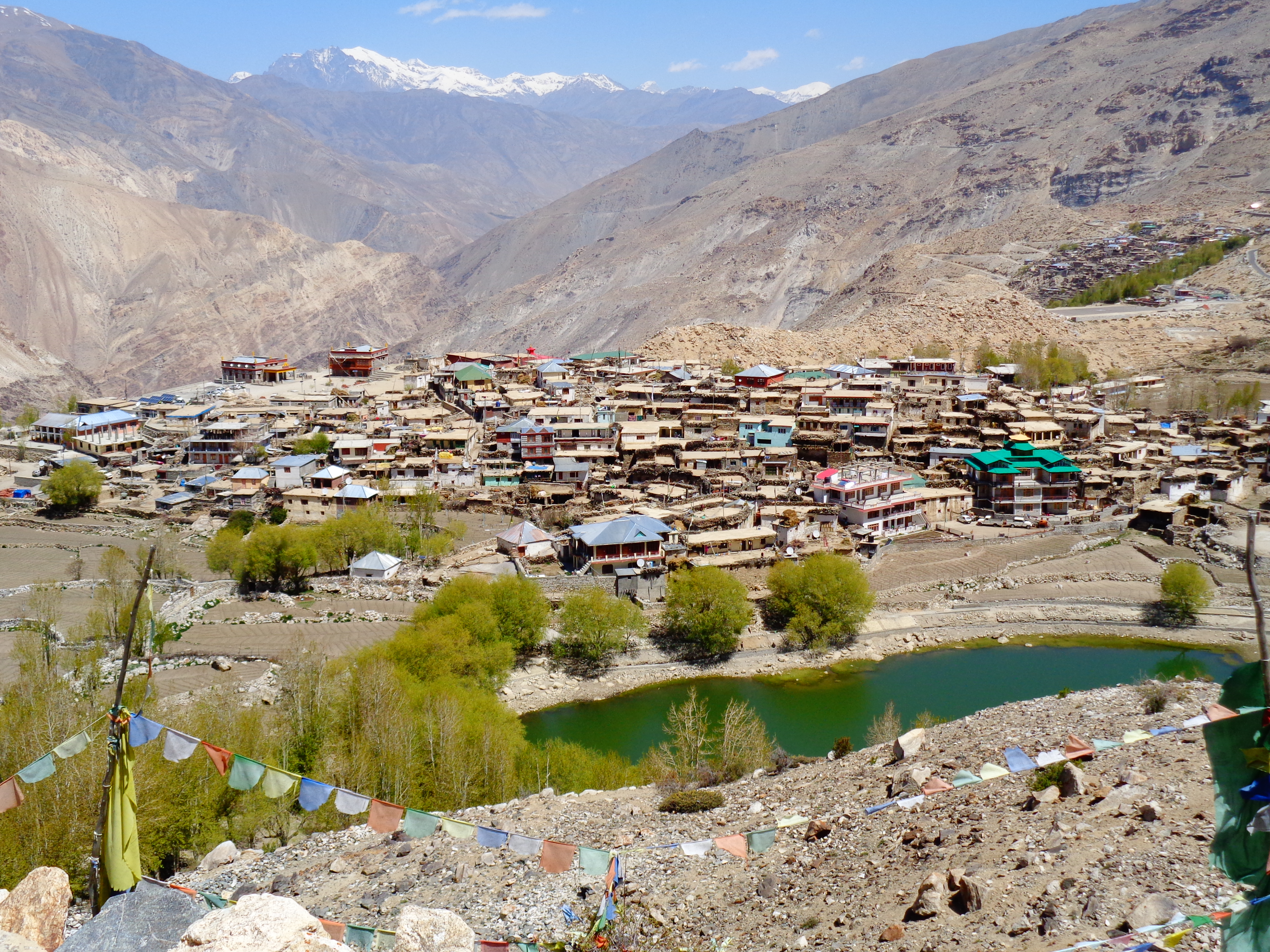
Tabo (3280m)
From Nako we managed to flag down a bus to Tabo, the last we would take for a while on this adventurous loop. We fell in love with magical little Tabo from the moment we arrived and where we stayed, Kesang Homestay, only added to the town’s allure. The homestay is run by an exceptionally friendly family, who gave us plenty of free chai and biscuits throughout our stay; they also cooked up some of the best Tibetan bread we have ever tasted!
Old Tabo Monastery
Tabo sits in a dramatic valley setting, hemmed in by rocky mountain slopes; apart from Kaza it is the only other town in Spiti. The main draw here is Old Tabo Monastery, which was founded in AD 996 by Ringchen Zangpo, the Great Translator; it is thought to be the oldest continuously functioning Buddhist monastery in India.
Five of the nine shrines date from the 10th and 11th Centuries, when they were painted by some of the best Buddhist muralists of their era – they are a blend of Tibetan, Indian and Kashmiri styles. The main assembly hall, the Tsuglkang, houses almost life-size clay sculptures of 32 bodhisattvas, which line the walls around a statue of a four-bodied Vairochana Buddha turning the wheel of law; below the bodhisattvas are murals depicting 10th Century life.
Other highlight early temples include the Ser-Khang (Golden Temple), with murals of the green Tara and the goddess Usnishavijaya, the Kyil-Khang (Mystic Mandala Temple), with a huge Vairochana mural surrounded by eight bodhisattvas, and the Byams-Pa Chen-Po Lha-Khang, with a 3m high statue of the Maitreya Buddha.
Tabo Old Monastery was a delight to explore; constructed of mud-brick and very low in height, it was completely different from any monastery we had ever seen before. Outside the compound lies a new modern gompa and a sparkling gilded chorten, which contrast so starkly with the original structure.

Whilst we were in town, we also climbed the hillside above the highway for stunning views over Tabo and the valley; patches of green stand out boldly against the otherwise barren landscape. Here are located a number of caves, which were once part of the monastery complex.
We would highly recommend eating at Café Kunzum Top whilst you’re in Tabo; the café/restaurant is attached to Sonam Homestay and offers some truly authentic local dishes including a Spitian thali, which is sure to be unlike any Indian thali you’ve ever tasted!
Dhankar (3894m)
From Tabo we hitched a ride on a pick-up truck (the crisp truck) to Sichling then from there rode with a local man in his car the final steep 8km up to Dhankar. High above the confluence of the Spiti and Pin Rivers, Dhankar is the former capital of the Nono kings who once ruled Spiti.
A magical, fairy-tale kind of place, the charm of this other-worldly village hit us immediately. We stayed at Manirang Homestay, a traditional white-washed home complete with stunning rooftop views and a compost toilet!

Dhankar Gompa
Perching precariously between eroded pinnacles on the edge of a cliff, 1200-year-old Dhankar Gompa is simply spectacular with phenomenal views from the top of the monastery buildings. Its top-floor courtyard has a stuffed blue sheep hanging above the stairwell, a room where the Dalai Lama slept, a meditation cave and a shrine containing ceremonial masks.
A modern new monastery lies 800m away from the photogenic original, which is where Dhankar’s lamas now live.
Dhankar Tso
Later that first afternoon, we set off for Dhankar Tso, a small turquoise lake an hour’s walk from the village. On the way we passed the hilltop ruins of a mud-brick fort that gave shelter to local people during times of war and gave Dhankar its name – dhak means ‘cliff’ and khar means ‘citadel’.
The hike up to the lake was a little slow going, unsurprising really given the fact that the lake lies at over 4000m above sea level; hiking uphill at this altitude is energy sapping. However, it is totally worth it! The views at the lake shore, with snow-capped mountain peaks in the background and the clouds reflected in the turquoise water, are stunning; the surrounding arid brown hills are a perfect contrast to such colour.

Lhalung
The following day we hiked 12km to the traditional village of Lhalung, hidden up the Lingti Valley. The village is known for its fantastic medieval monastery, which a monk opened up for us to have a look inside. There are some lovely old murals in the main chapel and, in the separate Langkharpo chapel, a unique four-sided statue of the white deity atop a plinth of snow lions. We found a fantastic homestay in which to have lunch then hitched a ride back to Dhankar.

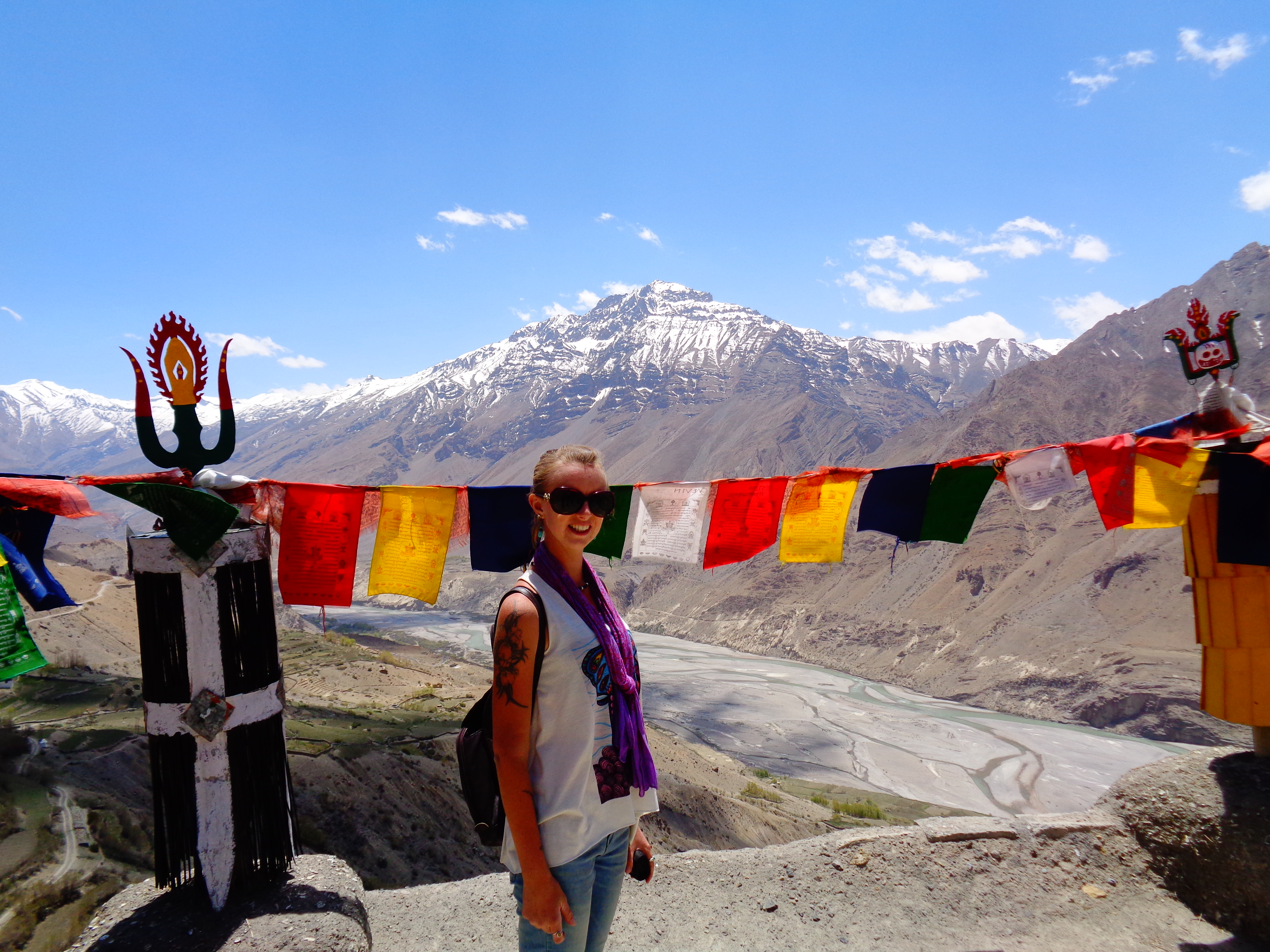
Kaza (3800m)
The capital of Spiti, Kaza is the largest settlement in the valley and sits on the eroded floodplain of the Spiti River with jagged mountains on either side. Aside from visiting the colourful Sakya Gompa or wandering the ramshackle bazaar, most people stay only a night or two in order to plan or arrange onward travel, obtain an inner-line permit or savour a few comforts from the many restaurants, cafes and bakeries around town.
Kaza is also the only place in Spiti where WIFI is a possibility, though not a certainty – it wasn’t working anywhere when we were in town!
Kaza makes a great base from which to branch out to the small high-altitude villages on the east side of the valley, which have a pristine, desolate beauty all their own. Many of the villages have homestays and it is possible to trek between them; a visit to one or all of them enables you to get a sense of the lifestyle of their amazingly resilient people.

Ki (4166m) and Kibber (4270m)
Having made it from Dhankar to Kaza by lunchtime, we decided to push on to Kibber, via Ki Monastery. Amazingly, we managed to do this by hitching a series of rides – the kindness of strangers we experienced in Spiti will never be forgotten! From Indian tourists with their own vehicles to locals delivering goods, we never had to wait long for someone to offer us a lift.
Ki Gompa, the largest in Spiti, sits picturesquely atop a conical hill and houses around 300 monks. The white-washed buildings include medieval prayer rooms, including one which houses a bed slept in by the Dalai Lama in 1960 and 2000.

The relatively large village of Kibber sits about 8km beyond Ki and is the trailhead for the demanding trek over the 5578m Parang La to Tso Moriri lake in Ladakh. It is also a great base for day hikes, if you’re not struggling with the altitude, which at this point, I was.
We stayed at a wonderful homestay, who cooked up some delicious food and helped me to feel better. The following morning we took a walk around the village and visited the small number of temples, one of which dates to the 14th Century and contains three prayer rooms with ancient wall paintings and sculptures.

From Kibber we hitched rides back to Kaza (including THE tractor), stayed one night then visited the villages of Langza, Hikkim and Komic by taxi the next day.
Langza (4420m)
Sitting below the pointed 6300m peak of Chau Chau, Langza is notable for its large modern Buddha statue that stares across the valley from the top of the village. There is also a 500-year-old temple behind it and, a half-hour-walk away, an area rich in ammonite fossils that are around 100 million years old.

Hikkim (4400m)
6km south of Langza, Hikkim is home to the world’s highest post office! Although it’s only open for two one-hour-slots a day, all customers are, apparently, offered a cup of tea.

Komic (4587m)
Komic, meanwhile, is claimed to be the highest village in the world connected to a motorable road – and there are plenty of signs to advertise it! Comprised of around 10 houses and, above them, the Tangyud Gompa, Komic is a kitschy little hamlet, worth stopping at for its unique photo ops. The gompa was founded around the 14th Century and currently houses about 50 monks.
Back in Kaza, we caught a late afternoon bus to Mudh in the Pin Valley, before returning to Kaza for one last night, ready for an early morning start to Manali the next day.
For what to see and do around Manali check out: Hitting the Hills in Manali!
Mudh (3770m)
We should really have visited Mudh after Dhankar but, due to the fact that we managed to hitch a ride all the way from Sichling to Kaza, we decided to see Kaza and its surrounding villages first and then take a bus to Mudh.
The road into the Pin Valley, in which Mudh is the final hamlet, branches off the Tabo road 15km from Kaza. The valley is wind-scoured but beautiful with the Pin River flowing from the heights of the Great Himalaya Range. If you have your own transport there are possible stop-off points on route to Mudh, including the 680-year-old Ugyen Sangnak Choling Gompa at Kungri, which contains medieval shrines with blackened murals, festival masks and carved wooden snow lions.
The tiny settlement of Mudh is the trailhead for the demanding trek to the Parvati Valley over the Pin-Parvati Pass (5319m) as well as the easier trek over the 4850m Bhaba Pass to Kaphnu in Kinnaur. Both treks enter the 675-sq-km Pin Valley National Park, reputed as the ‘land of ibex and snow leopards.’

We spent two peaceful nights at Tara Homestay, a traditional white-washed building with a very knowledgeable owner and delicious home cooked food. During our one whole day in Mudh, we enjoyed a short hike exploring the surrounding area but, unfortunately, logistical reasons meant that neither longer trek was possible this time round.
With the rushing blue Pin River, surrounding rocky hills, some snow-capped, and the smudge of green that envelopes Mudh, the landscape is, again, breathtakingly beautiful. Few travellers make it to this far-flung place – if you’re looking for a rural escape in Spiti, this could just be it.

If you’ve got a sense of adventure and a love for beautiful high-altitude Himalayan landscapes, we would highly recommend the incomparable Kinnaur Spiti loop. One of India’s most dramatic road trips, this route from the alpine greens of Kinnaur to the barren rocky highs of Spiti is challenging yet rewarding in equal measure!
For everything from the amazing local people to the incredible mountain scenery, Kinnaur Spiti was everything we expected and so, so much more. It is safe to say that, one day soon, we will find a way back to this sublime corner of India; we will do a hike from Kibber and we will camp at Chandratal Lake.
*Chandratal is a glacial lake that lies at the end of a track, 12km off the Kaza-Gramphu road. It is very difficult to reach without your own wheels!
If you enjoyed the Epic Kinnaur Spiti Loop, check out Ladakh, a region similar to Spiti but on a grander scale!

Made very enjoyable reading. Well written…Well done!
LikeLike